


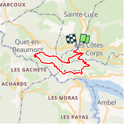
CORPS-Sentier d'interprétation de la Sezia

maupassant38
User

Length
12.7 km

Max alt
924 m

Uphill gradient
483 m
Km-Effort
19.2 km

Min alt
643 m

Downhill gradient
483 m
Boucle
Yes
Creation date :
2019-02-22 22:31:55.329
Updated on :
2019-02-22 22:31:55.347
3h59
Difficulty : Medium

FREE GPS app for hiking
 SityTrail
IGN / Geographical institutes
SityTrail Plus
The world is yours!
About
Trail Walking of 12.7 km to be discovered at Auvergne-Rhône-Alpes, Isère, Les Côtes-de-Corps. This trail is proposed by maupassant38.
Positioning
Country:
France
Region :
Auvergne-Rhône-Alpes
Department/Province :
Isère
Municipality :
Les Côtes-de-Corps
Location:
Unknown
Start:(Dec)
Start:(UTM)
729998 ; 4968427 (31T) N.
Comments